Skip to content
Identifying Pine Beetle Damage

Detecting Pine Beetle Damage with Satellite AI

Alberta's pine forests face widescale damage from Mountain Pine Beetle infestations — and early detection is the only effective intervention.
AltaML built a satellite imagery model that gives Forest Health Officers precise, GPS-accurate detection across the province, with the
potential to eliminate more than $1M in annual helicopter survey costs.

crop-monitoring
CLIENT

Government of Alberta
Forest Health and Adaptation branch

map-w-pin
PROJECT
Satellite imagery AI model to detect Mountain Pine Beetle infestations across Alberta's pine forests
computer-vision
WHAT WE DID

Computer vision model development, satellite imagery processing, and integration with existing Forest Health planning software

stopwatch-funding
IMPACT

$1M+ in projected annual savings from a 50% reduction in helicopter survey costs, with earlier and more precise infected tree detection
THE CHALLENGE

Mountain Pine Beetles spread fast. There is a narrow window between initial infection and the point where an infestation expands beyond cost-effective control, and identifying infected trees within that window requires province-wide coverage at pace.

For the Government of Alberta's Forest Health and Adaptation branch, that detection relied on helicopter surveys. Trained observers flew over forest areas, visually identifying the red and grey attack signatures of infected trees. The work was done by skilled people, but at $2.6 million per year, it was expensive.

Helicopter surveys also have inherent limits: coverage is constrained by flight time, scheduling, and weather, and the observations vary depending on the crew. The gap between when infestations start and when surveys can identify them created real risk. Delayed detection means broader spread, higher treatment costs, and greater damage to timber supply and wildfire risk across the province.

Forest Health needed a way to detect infestations faster and across more of the province — without the cost and scheduling constraints of aerial surveys.

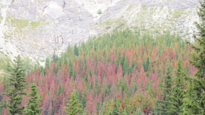
Forest infected by Alberta Pine Beetle

THE SOLUTION

AltaML built an AI model that processes high-resolution satellite imagery at 1.5m resolution to detect the visual signatures of MPB-infected trees at scale.

Using object detection, the model pinpoints individual infected trees from satellite imagery — not broad damage zone estimates, but precise GPS locations that Forest Health Officers can act on directly. 


Results are output in a format compatible with the branch's existing planning software, so the tool fits the workflows teams already use rather than requiring new systems or retraining. The model enables detection across the full province at the cadence satellite imagery allows, providing consistent and objective data regardless of crew variation or flight availability. For Forest Health Officers, it means the ability to identify infected areas before aerial surveys are dispatched — earlier in the spread cycle, when intervention is still cost-effective.

trending-down (white) $1M+ saved annually

Projected reduction in helicopter survey costs by 50%, from $2.6M to approximately $1.3M per year, freeing resources for on-the-ground management and response.

 
stopwatch-fast (white) Earlier detection Infected areas can be identified before aerial surveys are required, giving Forest Health Officers more lead time to intervene during the window when treatment is most effective.  
crosshair Precise, consistent data

GPS-accurate locations of infected trees replace variable estimates from helicopter observers, giving the branch a reliable data foundation for provincial control planning.
 

WHY IT MATTERS

Mountain Pine Beetle infestations left undetected kill trees, reduce Alberta's long-term timber supply, and increase wildfire risk at a provincial scale. Early, accurate detection is the difference between targeted intervention and large-scale loss.

Satellite-based AI detection gives Forest Health the coverage and speed that helicopter surveys can't match. With consistent data updated at satellite cadence across the full province, the branch can move from reactive aerial sweeps to a proactive detection model — one that scales without adding proportional cost.

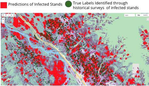
Pine Beetle Infection Satellite Detection

THIS IS WHAT ML LOOKS LIKE WHEN IT'S PUT TO WORK IN THE REAL WORLD.

See more of how we build for forestry, or reach out to our team — we'd love to hear about what you're trying to solve.